Welcome to our guide on the evolution of GPS technology, from its military beginnings to the everyday tools you rely on.
If you’re reading this, you likely depend on GPS for everything from navigating unfamiliar roads to tracking assets. But have you ever considered how this technology came to be? This article breaks down the critical milestones in GPS development, starting with its origins during the Cold War. You’ll learn how military needs drove its creation, the key events that transitioned GPS into civilian use, and how it has revolutionized sectors like aviation, transportation, and agriculture. We’ll also explore the pivotal decisions that made GPS accessible to everyone, starting with:
- Military Origins: The Cold War’s role in driving GPS development.
- Sputnik’s Impact: How a Soviet satellite launch sparked the creation of GPS.
- NAVSTAR GPS: The U.S. Department of Defense’s first global navigation system.
- Civilian Accessibility: The decision to share GPS after the Korean Air Lines Flight 007 tragedy.
- End of Selective Availability: How lifting restrictions in 2000 made GPS a tool for everyone.
- Industry Impact: The influence of GPS on aviation, agriculture, transportation, and mobile technology.
By the end, you’ll understand how GPS evolved and why it’s so vital today. Now, let’s dive into the journey of GPS from a military tool to an everyday necessity.
The Birth of GPS: Military Needs and Cold War Motivations
The need for precise navigation became increasingly evident during World War II. Military operations were often compromised by the limitations of traditional navigation tools like compasses and maps. The inaccuracies in these methods led to significant strategic challenges, particularly in complex terrains and under combat conditions. The U.S. military recognized that the ability to determine precise geographic locations could significantly enhance operational effectiveness. This realization marked the beginning of efforts to develop a more reliable navigation system.
As the Cold War began, the stakes grew higher. The competition between the United States and the Soviet Union extended beyond traditional battlefields to the realm of technological superiority. The U.S. military understood that superior navigation capabilities could provide a decisive advantage. The need for a global, all-weather navigation system that could function in any environment became a critical priority for national defense.
Early Navigation Challenges in Warfare
Before the advent of GPS, military navigation was fraught with challenges. Traditional methods, such as dead reckoning and celestial navigation, were prone to errors, especially in adverse conditions. For example, during the Cuban Missile Crisis in 1962, U.S. Navy submarines faced difficulties in determining their precise locations due to the limitations of existing navigation technologies. These inaccuracies posed significant risks in a world where nuclear deterrence depended on precision.
The limitations of these methods highlighted the need for a more advanced system that could provide continuous, accurate positioning information. The U.S. Department of Defense (DoD) began exploring the potential of satellite-based navigation as a solution. The goal was to create a system that could offer real-time location data with unprecedented accuracy, regardless of weather or time of day.
The Role of Sputnik in Igniting GPS Development
The launch of Sputnik by the Soviet Union in 1957 served as a pivotal moment in the history of GPS. Sputnik, the first artificial satellite, transmitted radio signals that could be tracked from Earth. This event spurred significant advancements in satellite-based navigation. Key developments include:
- Sergei Korolev: Chief designer of Sputnik, whose leadership and vision were instrumental in its successful launch.
- Doppler Effect Observation: Scientists at the Johns Hopkins University Applied Physics Laboratory, including Dr. William Guier and Dr. George Weiffenbach, measured the Doppler shift of Sputnik’s signals to determine its orbit. This method demonstrated the potential for satellite-based navigation.
- Transit System Development: Following Sputnik, the Transit system was developed by the U.S. Navy in the early 1960s. This was the first operational satellite navigation system and provided accurate location data for Navy submarines.
- ARPA Involvement: The Advanced Research Projects Agency (ARPA), now known as DARPA, played a critical role in funding early research into satellite navigation, recognizing its military potential.
The insights gained from tracking Sputnik laid the groundwork for the more sophisticated GPS system. As the Cold War intensified, the U.S. military realized the necessity for a global, continuous, and accurate navigation system that could serve all branches of the armed forces. This realization fueled further research and development, eventually leading to the creation of GPS.
The drive to develop GPS was motivated by the need to maintain military superiority during the Cold War. The U.S. invested heavily in this technology, recognizing its potential to revolutionize military operations and, eventually, civilian applications. This early focus on military needs and Cold War dynamics was the foundation upon which modern GPS technology was built. Now, lets take a closer look at the development during the Cold War.
U.S. Department of Defense and the Creation of NAVSTAR GPS (Development During the Cold War)
The Cold War era was a time of rapid technological advancement, driven by the intense rivalry between the United States and the Soviet Union. During this period, the U.S. Department of Defense (DoD) recognized the strategic importance of a global navigation system. The result was the development of NAVSTAR GPS (Navigation System with Timing and Ranging), a project initiated in 1973 under the direction of the DoD. Now, lets take a closer look at some of the key milestones in the creation of NAVSTAR GPS include:
- 1973: The U.S. Air Force initiated the NAVSTAR GPS program to integrate existing satellite navigation technologies into a single, cohesive system. This marked the official beginning of the GPS we know today.
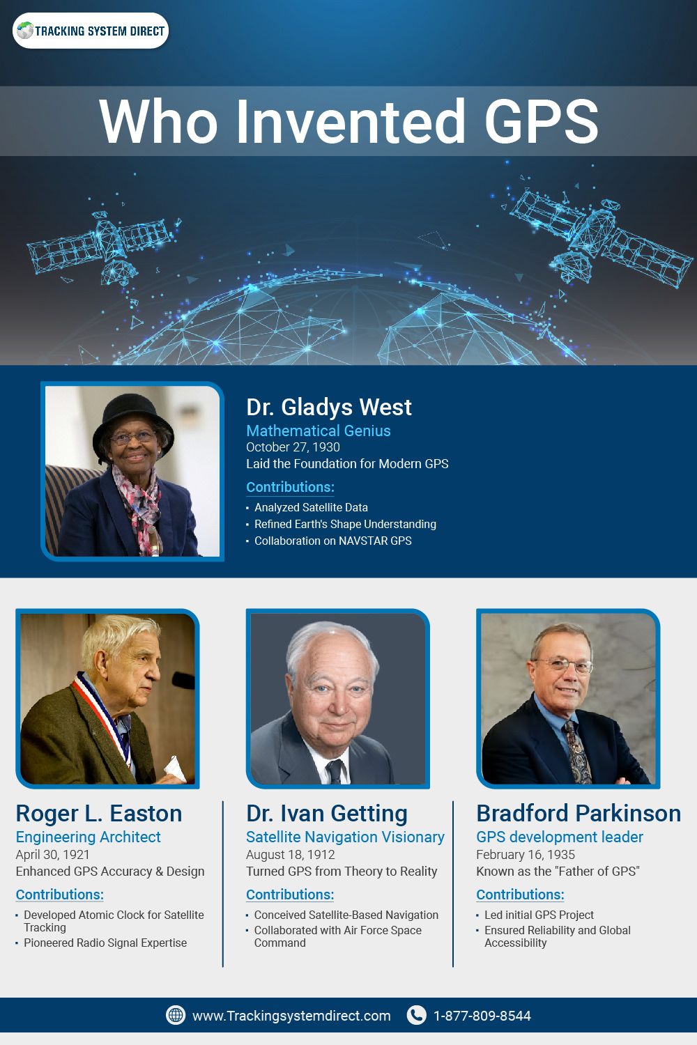
- Dr. Bradford Parkinson: Often referred to as the “Father of GPS,” Dr. Parkinson played a pivotal role in the development of NAVSTAR GPS, and was part of group of collective geniuses who invested GPS. His leadership ensured that the system met the stringent requirements of military operations.
- Development Phases: The GPS program was divided into several phases, including concept validation, technology demonstration, and full-scale development. Each phase was critical in refining the system’s accuracy and reliability.
Initial Military Applications: Precision in Missile Guidance and Troop Movements
The primary motivation behind the development of GPS was its potential to enhance military capabilities. During the Cold War, the U.S. military needed a system that could provide precise location data in real-time, anywhere on Earth. This need was especially critical for missile guidance and troop movements.
- Missile Guidance: One of the earliest applications of GPS was in the guidance systems of intercontinental ballistic missiles (ICBMs). Accurate positioning was essential to ensure that these missiles could reach their targets with pinpoint precision, minimizing collateral damage and maximizing strategic impact.
- Troop Movements: GPS also revolutionized troop movements, enabling military commanders to coordinate complex maneuvers with unprecedented accuracy. For example, during the Gulf War in 1991, GPS played a crucial role in the successful execution of Operation Desert Storm, allowing U.S. forces to navigate the featureless deserts of Iraq and Kuwait.
The development of NAVSTAR GPS during the Cold War was driven by the need to maintain military superiority. This system provided the U.S. military with a significant tactical advantage, allowing for precision in missile guidance and the effective coordination of troop movements. Over time, these military applications laid the groundwork for the civilian uses of GPS that we rely on today.
Global Accessibility: Government Decisions to Share GPS Technology
The initial development of GPS was driven by military needs, but its potential for civilian applications became increasingly apparent. By the late 1970s and early 1980s, the U.S. government began to consider the benefits of making GPS technology available to the public. The decision to share this technology was not made lightly, as it involved balancing national security concerns with the potential for widespread benefits. However, there were some key factors in this decision such as:
- Dual-Use Potential: GPS technology was recognized as having dual-use potential, meaning it could be utilized for both military and civilian purposes. This potential encouraged policymakers to explore broader applications beyond the battlefield.
- Pressure from Industry and Academia: Various sectors, including aviation, maritime, and scientific research, began to advocate for access to GPS technology. They saw its potential to revolutionize navigation, communication, and data collection.
The Downing of Korean Air Lines Flight 007
A tragic event in 1983 played a crucial role in the decision to make GPS available for civilian use. On September 1, 1983, Korean Air Lines Flight 007 was shot down by the Soviet Union after it strayed into restricted airspace. The incident resulted in the loss of 269 lives and highlighted the limitations of existing navigation systems.
- Flight 007’s Navigation Error: The aircraft’s navigation system had led it off course, inadvertently crossing into Soviet airspace. This navigation error was a stark reminder of the limitations of the technology available at the time.
- President Ronald Reagan’s Decision: In response to this tragedy, U.S. President Ronald Reagan announced that GPS would be made available for civilian use once fully operational. His decision was a direct effort to prevent similar incidents in the future by providing pilots with access to more accurate navigation tools.
The Decision to Make GPS Available for Civilian Use
Following the downing of Korean Air Lines Flight 007, the U.S. government recognized the urgent need for more precise navigation systems accessible to the public. This tragedy accelerated the decision to expand GPS technology beyond military use. Initially, GPS signals available to civilians were intentionally degraded under a policy known as Selective Availability (SA). This policy ensured that the military maintained superior navigational accuracy, a crucial factor during the Cold War. Even with this limitation, GPS was a groundbreaking tool for civilian applications, providing a level of accuracy that was previously unattainable.
However, the potential of GPS was truly unlocked when President Bill Clinton ordered the end of Selective Availability in May 2000. This decision allowed civilians to access the full accuracy of GPS signals, transforming the technology into a powerful tool for everyday use. The removal of SA had a profound impact on industries such as aviation, where precise navigation is critical, and transportation, where it enabled more efficient routing and logistics. It also revolutionized personal navigation, giving rise to tools like Google Maps, which millions now rely on daily for directions and location-based services.
The end of SA also paved the way for innovations in GPS tracking, from fleet management systems that monitor vehicle locations in real-time to hidden GPS trackers used for security and asset protection. By making GPS technology fully accessible to civilians, the U.S. government not only enhanced public safety but also sparked a wave of technological advancements that continue to shape how we navigate and interact with the world today.
First Civilian Applications – Early Adopters in Aviation, Maritime, and Geolocation Services
After the U.S. government made GPS available for civilian use, it didn’t take long for various industries to recognize its potential. Aviation and maritime sectors were among the first to incorporate GPS, seeing immediate benefits in navigation accuracy. For airlines, the ability to plot precise flight paths reduced fuel consumption and improved safety, particularly during long-haul international flights. Similarly, the maritime industry adopted GPS to enhance the safety and efficiency of oceanic navigation, offering captains a reliable tool to determine their exact position at sea, regardless of weather conditions.
Geolocation services were another early adopter of GPS technology. These services leveraged the precision of GPS to develop detailed mapping and navigation systems that could be used for a wide range of applications, from surveying to outdoor recreation. Although the initial civilian applications of GPS were somewhat limited by the Selective Availability (SA) feature, the removal of SA in 2000 allowed these industries to fully exploit the technology’s capabilities.
Impact on Various Industries
The deactivation of Selective Availability in 2000 marked a turning point in the commercial use of GPS. Once civilians had access to the full accuracy of GPS signals, a wave of innovation followed. The agricultural industry, for instance, began using GPS for precision farming. This technology allowed farmers to monitor and manage their fields with remarkable accuracy, leading to optimized planting, fertilization, and harvesting processes that increased crop yields and reduced costs.
In transportation and logistics, GPS became indispensable for route optimization and fleet management. Companies could now track their vehicles in real time, ensuring more efficient deliveries and better customer service. This not only streamlined operations but also significantly cut down on fuel consumption and operational costs. The impact was so profound that GPS quickly became a standard feature in commercial transportation.
The integration of GPS into mobile technology also expanded its influence. As smartphones became ubiquitous, location-based services (LBS) like Google Maps, ride-sharing apps, and social media geotagging transformed how people interact with their surroundings. GPS enabled users to navigate unfamiliar cities, find nearby restaurants, and even track their exercise routines with unprecedented ease.
Here’s a concise breakdown of how GPS has permeated various industries, demonstrating its broad impact:
| Industry | Primary Use | Technology | Impact |
| Aviation | Flight navigation | GPS receivers | Enhanced safety |
| Maritime | Oceanic navigation | Marine GPS | Accurate positioning |
| Agriculture | Precision farming | GPS mapping | Optimized crop yields |
| Transportation | Route optimization | Fleet GPS | Increased efficiency |
| Mobile Technology | Location services | Smartphone GPS | Location-based apps |
The widespread adoption of GPS across these industries showcases its transformative power. From optimizing global logistics networks to powering the apps on your smartphone, GPS technology has become a foundational element of modern life, influencing how we travel, work, and connect with the world around us.
Conclusion
The evolution of GPS technology is a testament to how military innovation can transform into a vital tool for everyday life. What began as a strategic advantage during the Cold War has grown into a global utility that touches nearly every aspect of modern society. From its military roots, where precision in missile guidance and troop movements was critical, to the pivotal decision to make GPS available to civilians, each milestone has shaped the way we navigate the world today.
The end of Selective Availability in 2000 was a significant turning point, unlocking the full potential of GPS for civilian use. This shift led to innovations across various industries, from aviation and maritime navigation to precision farming and mobile technology. GPS has become an integral part of our lives, guiding us through unfamiliar cities, optimizing logistics, and enhancing personal and public safety.
As GPS technology continues to evolve, its impact will only grow, further embedding itself into the fabric of modern life. Understanding its journey from a military tool to a cornerstone of global connectivity not only highlights its significance but also reminds us of the power of innovation to drive progress.


